Original Data
| Rev Diabet Stud,
2017,
14(4):381-389 |
DOI 10.1900/RDS.2017.14.381 |
Association of Socio-Environmental Determinants with Diabetes Prevalence in the Athens Metropolitan Area, Greece: A Spatial Analysis
Antigoni Faka1, Christos Chalkias1, Diego Montano2, Ekavi N. Georgousopoulou3,4, Anestis Tripitsidis1, Efi Koloverou3, Dimitris Tousoulis5, Christos Pitsavos5, Demosthenes B. Panagiotakos3
1Department of Geography, School of Environment, Geography and Applied Economics, Harokopio University, Athens, Greece
2Clinic for Psychosomatic Medicine and Psychotherapy, Ulm University, Ulm, Germany
3Department of Nutrition and Dietetics, School of Health Science and Education, Harokopio University, 17671 Athens, Greece
4Faculty of Health, University of Canberra, Canberra, Australia
5First Cardiology Clinic, School of Medicine, University of Athens, Greece
Address correspondence to: Demosthenes B. Panagiotakos, e-mail: dbpanag@hua.gr
Manuscript submitted January 15, 2018; resubmitted March 2, 2018; accepted March 3, 2018.
Keywords: diabetes, socio-environmental factor, socioeconomic, Geographic Information System
Abstract
OBJECTIVES: The aim of this study was to investigate the spatial variation of diabetes in relation to the geographical variability of socio-environmental characteristics in the urban districts of Athens. METHODS: A sample of 2,445 individuals from the greater area of Athens was randomly enrolled in the ATTICA study between 2001 and 2002. Diabetes was defined according to American Diabetes Association criteria. Geographical and statistical analyses were applied to examine the relationship between diabetes prevalence and factors related to education, economic status, population density, immigrant status, and availability of urban green areas. Diabetes prevalence and socio-environmental factor mapping was based on the Geographic Information Systems (GIS) technology. Variograms and spatial quasi-Poisson regression analysis evaluated the associations of diabetes with the socio-environmental variables at the municipal level. RESULTS: According to the geographical analysis and mapping, the highest proportions of people with diabetes were found in the West sector and in one district of the East and South sector each. Regression analysis revealed that the proportion of inhabitants with higher education is negatively correlated with diabetes prevalence in the regional areas of Athens. CONCLUSIONS: The study revealed that socio-environmental status in residential areas, especially educational and economic levels, is correlated with diabetes prevalence at the aggregate level. These correlations may reflect socio-economic segregation patterns at the district level, and different prevalence rates of diabetes among individuals with higher income and educational levels.
Abbreviations: CVD - cardiovascular disease; CS - central sector; EEA - European Environment Agency; ES - east sector; GIS - Geographic Information Systems; GLMM - generalized linear mixed model; ISCED - International Standard Classification of Education; NCD - non-communicable disease; NS - north sector; SES - socioeconomic status; SS - south sector; WS - west sector
1. Introduction
Diabetes mellitus has long been associated with severe vascular complications, including cardiovascular disease (CVD), kidney failure, blindness, lower limb amputation, and nerve damage, which cause quality of life to degrade and premature mortality to rise [1-2]. The prevalence of diabetes is escalating worldwide, making it a high-priority non-communicable disease (NCD) targeted for action by world leaders. The global prevalence of diabetes has nearly doubled since 1980, rising from 4.7% to 8.5% in the adult population, especially in low- and middle-income countries [2-3]. Type 2 diabetes is the most common form of diabetes, accounting for 80% to over 95% of cases, depending on regional differences [4]. In many studies, the global burden of type 2 diabetes has been associated with multiple lifestyle-related factors, such as overweight and obesity, lack of exercise, unhealthy diet, and smoking, leading synergistically to a higher risk of CVD and other related cardiometabolic disorders [5].
At the same time, observational studies have indicated that diabetes prevalence is related to different aspects of the socioeconomic status (SES) of individuals, including education level, income, and occupational prestige [6]. The main mechanisms accounting for these findings are thought to be based on inappropriate health-related behavior, deficient diabetes-related knowledge, insufficient access to and use of care, and unaffordability of healthy food, among other factors [6-7]. Given that the spatial distribution of individuals in geographical regions largely depends on key socioeconomic characteristics of individuals and regions (e.g., income and real estate prices), health outcomes may also be based on geographical patterns [8]. For instance, Tyrovolas et al. found that the altitude of residency may be associated with the occurrence of the metabolic syndrome and diabetes [9].
Socio-environmental characteristics of a residential area can be described by two kinds of data, namely:
- Aggregate individual-level data, including income, educational level, and health outcome.
- Geographical data, including population density and the availability of green and recreational spaces.
With these data geospatial analysis can be applied to analyze the joint spatial distribution of health outcomes (e.g. diabetes prevalence) and socio-environmental characteristics of neighborhoods [10].
However, most epidemiological studies have focused on the association between diabetes and SES [11-14]. Relating the geographical variability of diabetes to socio-environmental characteristics may result in increased knowledge into the diabetes-SES relationship at a population level, but such research is limited in the literature [15-16]. In this regard, the aim of the present study was to investigate the spatial variation of diabetes in the Athens metropolitan area in relation to the geographical availability and variability of socio-environmental characteristics in the urban districts of Athens.
2. Methods
2.1 Sample data
The ATTICA study started in 2001 and included two follow-ups, at 5 and 10 years. It was carried out in the greater area of Athens (including 78% urban and 22% rural regions) [17]. At baseline (2001-2002), 4,056 inhabitants from the above area were invited to participate in the study. After excluding those with CVD (i.e., n = 117) and those with chronic viral infections (n = 107), 3,042 finally agreed to participate (75% participation rate); 1,514 were men (18-87 years) and 1,528 were women (18-89 years). The individuals were examined at their home or place of work by trained personnel (cardiologists, general practitioners, dieticians, and nurses) [18]. The sample size used in this study included 2,445 individuals with complete data for geographical identification and assessment of diabetes status. More details about the aims, design, and methods used in the ATTICA study may be found elsewhere [17].
2.2 Socio-environmental data
For regional assignment of participants in the present analysis, we used the participants’ residential addresses, which were recorded during the ATTICA study. The selected variables are related to environmental factors and living conditions that may directly or indirectly impact health behavior. Obesity, which is a strong risk factor for diabetes [5], is highly correlated with poor diet and low area-level SES status [8, 19, 20]. The odds for unhealthy diet are increased in areas with lower education levels [21] and in lower-income neighborhoods where obesity rates are higher [22]. Racial and ethnic composition is another factor which is used as a crude proxy for a variety of socioeconomic characteristics [8].
Furthermore, existing evidence indicates that immigrants tend to follow "obesogenic" dietary practices and have an increased risk of physical inactivity [23-24]. Physical inactivity is also described as a risk factor for diabetes; it is affected by physical environment and lack of green and recreational areas which promote sedentary lifestyle [25-26]. Lovasi et al. reported that the availability of high green-space rates and low population density were associated with increased physical activity [27].
The variables we used to define the socio-environmental status included:
- Average real estate prices and average annual income (year 2009) obtained from the General Secretariat for Information Systems of the Greek Ministry of Economy and Finance.
- Percentage of illiterate population (not completed primary school, i.e. ISCED level 0) [28].
- Percentage of the population with higher education (completed upper secondary education or have received a degree from a university or technical institute, i.e. ISCED levels 3-6).
- Percentage of immigrants in the total population and their population density (residents per km2), based on 2011 census data of the Statistical Authority of Greece.
- Percentage of green urban areas in the total area of each district, based on land-use data for the reference year 2006, from Urban Atlas, European Environment Agency (EEA).
2.3 Diabetes diagnosis
Diagnosis of type 2 diabetes was based on the criteria of the American Diabetes Association, i.e., fasting blood glucose >125 mg/dl or the use of antidiabetic medication [29].
2.4 Spatial data
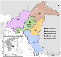
In the present study, the spatial units of analysis were the metropolitan area sectors and districts of Athens. The subdivision of the metropolitan area into sectors was based on the fact that the study area is characterized by spatial heterogeneity and socioeconomic disparities regarding social characteristics, economic level, nationality, and others [30-31]. For this reason, and based on studies relevant to social segregation in Athens [32-33], the study area was divided into five sectors, each sector comprising districts with largely homogenous socio-environmental characteristics (see Figure 1):
- East sector (Es): 7 districts, 374,816 residents, 391 participants
- South sector (Ss): 7 districts, 437,171 residents, 288 participants
- West sector (Ws): 11 districts, 775,014 residents, 548 participants
- North sector (Ns): 10 districts, 496,025 residents, 326 participants
- Central sector (Cs): 5 districts, 1,055,101 residents, 892 participants
 |
 |
Figure 1. Athens metropolitan area and spatial units of reference (sectors and districts, 2015). |
|
2.5 Geographical analysis
The geographical analysis was performed using Geographic Information Systems (GIS), a geospatial technology commonly used in area-based health studies [10, 34]. A spatial database was created in which GIS layers of spatial units (sectors) of reference were recorded. Socio-environmental data and data related to the observations of the ATTICA study were geocoded and aggregated for the respective districts through a series of GIS-supported procedures. Geocoding of diabetes data was based on the residential address of each participant in the ATTICA study by attributing each observation to the district in which the participant was residing. The aggregation was performed by summing up the observations per district to calculate the total number of people with diabetes in each spatial unit (i.e., sectors 1-5).
To normalize disease values, the number of people with diabetes per district was expressed as proportion per 1,000 observations. Geocoding and aggregation procedures were repeated for socioeconomic and environmental data, and the respective variables were calculated. As a result, each socio-environmental variable had one value per spatial unit (i.e. sector).
Subsequently, the values of each variable were classified into five classes using the "natural breaks" method. "Natural breaks" is a classification method designed to arrange values into different classes by seeking to minimize each class’s average deviation from the class mean, while maximizing each class’s deviation from the means of the other classes [35]. By this means, the variance within classes is reduced and that between classes is maximized. The output of this final procedure was a series of thematic maps that demonstrated socio-environmental status and diabetes prevalence across the districts of the five sectors. ArcGIS version 10.2 (ESRI Inc., Redlands, California, USA) software was used for all geographical analysis procedures.
2.6 Statistical analysis
Associations between socio-environmental predictors and diabetes prevalence were examined using variogram and regression analysis for spatial data. The variogram in spatial statistics represents the covariance between observations of a variable measured at different geographical locations, and is equivalent to the correlation analysis in statistics. However, the variogram also takes into account the fact that measurement points are not independent of each other [36].
Spatial regression analysis was performed by estimating a generalized linear mixed model (GLMM). In order to account for overdispersion of diabetes cases and the spatial correlation of observations, the estimation procedure consisted of a quasi-Poisson regression with a Gaussian spatial correlation structure [36, 37]. In addition, spatial correlations between population density and diabetes cases were taken into account by considering population density as an ordered categorical variable with five categories in the random-effects part of the quasi-Poisson model. Variable selection was based on the results obtained from the variogram. Independent variables were the percentage of the population with higher education, and the percentage of green urban areas in the districts. The dependent variable was the number of diabetics per 1,000 residents in the corresponding districts.
Variogram and spatial regression analyses were estimated with the routines implemented in the gstat and MASS packages of the statistical environment R [38, 39].
3. Results
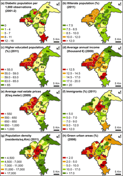
Figure 2 shows the spatial distribution of diabetes prevalence and all socio-economic and environmental variables, demonstrating the spatial and socioeconomic inequalities across the districts of Athens. Specifically, Figure 2a indicates that diabetes proportions differ among the sectors and districts within the sectors. The highest numbers were found to be concentrated in Ws and in two districts of Es and Ss. Regarding the thematic maps of the socio-environmental variables, Ws was also identified as a sector with low socio-environ-mental status according to most indicators. Particularly, Ws had the lowest educational level, as it included the highest proportion of illiterate population and the lowest proportion of higher educated population across all its districts (Figures 2b and 2c).
The population in Cs also had a lower educational status compared with the residents in other sectors (Figure 2c). With regard to economic level, the lower-income population lived in Ws and Cs (Figure 2d), and Ws had the lowest real estate prices (Figure 2e). In contrast, Ns included the higher-income population, and along with the southern municipalities of Ss, they scored highest regarding real estate prices (Figures 2d and 2e).
The highest proportion of immigrants and the highest population density were observed in Cs and some of the neighboring districts (Figures 2f and 2g). The highest proportion of green urban areas was present in the northern districts of Cs and in some districts of Ns, whereas few green urban areas existed in Ws, Es, and Ss (Figure 2h).
 |
|
Figure 2. Thematic maps of diabetes prevalence and socio-environmental variables. The maps show the spatial distribution of (a) diabetes prevalence, (b) illiterate population, (c) higher educated population, (d) average annual income, (e) average real estate prices, (f) immigrants, (g) population density, and (h) green urban areas across the districts of Athens. Sectors are highlighted by thick dark grey borderlines. |
|
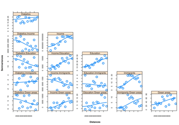
The results of the variogram analysis are summarized in Figure 3. In each panel of Figure 3, the covariance of the corresponding socio-environmental variables and diabetes cases is plotted against the distance between observation points. The panels in the diagonal show the variograms of a single variable, whereas the off-diagonal elements indicate the cross-variograms of variable pairs. The slopes of the lines included in each panel represent the degree of spatial clustering of observations in the districts of Athens for the variables considered. The upper left panel of Figure 3 shows that there was no strong spatial clustering of diabetes cases; they were in fact distributed regularly across the districts. The cross-variograms show that only income, education, and green urban areas were associated with the spatial distribution of diabetes cases. In particular, the cross-variogram between income and education reveals that these variables were highly correlated, and show a strong tendency towards geographical clustering.
 |
|
Figure 3. Variograms of diabetes cases and socio-environmental variables. Continuous lines were calculated on a variogram model using a Gaussian spatial correlation structure with nugget parameter 0.1. |
|
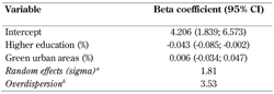
On the basis of the variogram results, the covariates of the quasi-Poisson regression analysis reported in Table 1 were restricted to education (i.e., percentage of the population with higher education), and the percentage of green urban areas. The coefficient estimate of education revealed that the percentage of higher education in the districts was associated with a 4.3% decrease in diabetes prevalence. In contrast, the percentage of green urban areas did not seem to be associated with diabetes incidence at the aggregate level (0.006, 95% CI: -0.034; 0.047, Table 1).
Table
1.
Variable Beta coefficient (95% CI) Intercept 4.206 (1.839; 6.573) Higher education (%) -0.043 (-0.085; -0.002) Green urban areas (%) 0.006 (-0.034; 0.047) Random effects (sigma)a 1.81 Overdispersionb 3.53 |
|
 |
|
Legend:
The beta coefficients represent the average deviations from the overall mean (i.e. the intercept) in the logarithmic scale. a A total of five random effect levels according to population density intervals in ascending order (i.e. from less densely populated to most densely populated) were included. b The overdispersion coefficient accounts for additional variance not captured by the simple Poisson model. Values greater than 1 mean that the data show larger variation than expected from the simple Poisson model. |
|
4. Discussion
The aim of the present study was to examine the spatial distribution of diabetes in relation to socio-environmental characteristics in the districts of the Athens metropolitan area (Greece). The study area was characterized by social segregation [32-33], which was reflected by the distribution patterns of diabetes and socio-environmental factors across the different sectors.
The regression analysis revealed a negative spatial correlation between the percentage of inhabitants with higher education and diabetes prevalence. This clustering pattern of education and diabetes prevalence at the municipal level agrees with previous findings based on individual-level data, which indicated a negative association between higher education and diabetes risk [40-41]. Since income and education are highly correlated (Figure 3), our findings suggest that individuals with higher educational and income levels tend to build geographical clusters where diabetes prevalence is lower. This observation also seems to agree with a previous study in the United Kingdom demonstrating that, among women, the relative odds of diabetes at the individual level decrease with higher income levels [42].
Neither spatial correlation nor regression analysis showed a joint distribution pattern between the proportion of immigrants, green urban areas, and diabetes cases at the municipal level. These results are contradictory to the assumption that areas with high scores of green and recreational spaces motivate people to adopt physically active lifestyles [25-27]. Our findings suggest that the potential protective effects of physical activity on diabetes prevalence in the Athens metropolitan area are not related to the availability of green areas, but rather to education-related lifestyle factors.
The impact of individual socioeconomic status on diabetes has been investigated in many studies, including previous publications of the ATTICA study [13-14, 40-41, 43]. However, in contrast to previous studies, a geographical dimension was added to the investigation of the relation between SES factors and diabetes, which offers a new view on the role of socioeconomic factors in the risk of diabetes. The use of GIS-based methods and thematic maps contributes to a better understanding of spatial distribution patterns related to diabetes prevalence in metropolitan areas [21, 44]. Furthermore, since the associations reported in the present study explicitly model the spatial dependences between observed socio-environmental variables, they hold true despite inter-municipal variations.
A limitation of the present work is that only 40 geographical units were available for investigation. This means that socioeconomic disparities within districts could not be considered for a possible improvement of the precision and efficiency of estimates. Another limitation is related to the different reference years of the variables, which may have caused additional variance to the estimates. However, because of the small time period between the reference years (i.e., 2009 vs. 2011) the variables (e.g., the percentage of green urban areas) were not expected to vary considerably. Therefore, the additional variance caused by the different reference years was considered to be insignificant.
Finally, in future research, it would be interesting to examine the role of other mediators at the geographical and individual level, e.g. availability of fresh foods, food consumption behavior, and diabetes-related knowledge, which could not be investigated in the present study because of the unavailability of appropriate data.
5. Conclusions
The present study showed that socio-environ-mental variables in residential areas, especially education and economic status, are correlated with diabetes prevalence at the aggregate level. These correlations may reflect socioeconomic segregation patterns at the municipal level since there were lower prevalence rates of diabetes among individuals with higher income and educational levels. This association was obtained with geographical data and corroborates previous findings indicating lower diabetes prevalence among individuals with higher educational levels.
Funding: The ATTICA Study has been funded by research grants from the Hellenic Cardiology Society and the Hellenic Atherosclerosis Society.
Disclosures: The authors reported no conflict of interests.
References
- Wang H, Naghavi M, Allen C, Barber RM, Bhutta ZA, Carter A, Casey DC, Charlson FJ, Chen AZ, Coates MM, et al. Global, regional, and national life expectancy, all-cause mortality, and cause-specific mortality for 249 causes of death, 1980-2015: a systematic analysis for the Global Burden of Disease Study 2015. Lancet 2016. 388(10053):1459-1544. [DOD] [CrossRef]
- World Health Organization. Global report on diabetes. Available online at: http://apps.who.int/iris/bitstream/ 10665/204871/1/9789241565257_eng.pdf. Accessed November 16, 2017. [DOD]
- Zhou B, Lu Y, Hajifathalian K, Bentham J, Di Cesare M, Danaei G, Bixby H, Cowan MJ, Ali MK, Taddei C, et al. Worldwide trends in diabetes since 1980: a pooled analysis of 751 population-based studies with 4.4 million participants. Lancet 2016. 387(10027):1513-1530. [DOD] [CrossRef]
- Whiting D, Unwin N, Roglic G. Diabetes: equity and social determinant. In: Blas E, Kurup Sivasankara A (eds.). Equity, social determinant and public health programmes. World Health Organization 2010. pp 77-94. Available online at: http://apps.who.int/iris/bitstream/10665/44289/1/9789241563970_eng.pdf. Accessed November 19, 2017. [DOD]
- GBD 2013 Risk Factors Collaborators, Forouzanfar MH, Alexander L, Anderson HR, Bachman VF, Biryukov S, Brauer M, Casey D, Coates MM, Delwiche K, et al. Global, regional, and national comparative risk assessment of 79 behavioural, environmental and occupational, and metabolic risks or clusters of risks in 188 countries, 1990-2013: a systematic analysis for the Global Burden of Disease Study 2013. Lancet 2015. 386(10010):2287-2323. [DOD] [CrossRef]
- Brown AF, Ettner SL, Piette J, Weinberger M, Gregg E, Shapiro MF, Karter AJ, Safford M, Waitzfelder B, Prata PA, Beckles GL. Socioeconomic position and health among persons with diabetes mellitus: a conceptual framework and review of the literature. Epidemiol Rev 2004. 26:63-77. [DOD] [CrossRef]
- Stringhini S, Batty GD, Bovet P, Shipley MJ, Marmot MG, Kumari M, Tabak AG, Kivimäki M. Association of lifecourse socioeconomic status with chronic inflammation and type 2 diabetes risk: The Whitehall II Prospective Cohort Study. Plos Med 2013. 10: e1001479. [DOD] [CrossRef]
- Diez Roux AV, Mair C. Neighborhoods and health. Ann N Y Acad Sci 2010. 1186:125-145. [DOD] [CrossRef]
- Tyrovolas S, Chalkias C, Morena M, Tsiligianni I, Zeimbekis A, Gotsis E, Metallinos G, Bountziouka V, Polychronopoulos E, Lionis C, Panagiotakos D. Health care access and prevalence of the metabolic syndrome among elders living in high-altitude areas of the Mediterranean islands: the MEDIS study. Rev Diabet Stud 2011. 8(4):468-476. [DOD] [CrossRef]
- Schlundt DG, Hargreaves MK, McClellan L. Geographic clustering of obesity, diabetes, and hypertension in Nashville, Tennessee. J Ambul Care Manage 2006. 29(2):125-132. [DOD] [CrossRef]
- Bihan H, Laurent S, Sass C, Nguyen G, Huot C, Moulin JJ, Guegen R, Toumelin PL, Le Clesiau H, et al. Association among individual deprivation, glycemic control and diabetes complications: the EPICES score. Diabetes Care 2005. 28(11):2680-2685. [DOD] [CrossRef]
- Du Prel JB, Icks A, Grabert M, Holl RW, Giani G, Rosenbauer J. Socioeconomic conditions and type 1 diabetes in childhood in North Rhine-Westphalia, Germany. Diabetologia 2007. 50(4):720-728. [DOD] [CrossRef]
- Hwang J, Shon C. Relationship between socioeconomic status and type 2 diabetes: results from Korea National Health and Nutrition Examination Survey (KNHANES) 2010-2012. BMJ Open 2014. 4(8):e005710. [DOD] [CrossRef]
- Jaffiol C, Thomas F, Bean K, Jego B, Danchin N. Impact of socioeconomic status on diabetes and cardiovascular risk factors: results of a large French survey. Diabetes Metab 2013. 39(1):56-62. [DOD] [CrossRef]
- Connolly V, Unwin N, Sherriff P, Bilous R, Kelly W. Diabetes prevalence and socioeconomic status: a population based study showing increased prevalence of type 2 diabetes mellitus in deprived areas. J Epidemiol Community Health 2000. 54(3):173-177. [DOD] [CrossRef]
- Auchincloss AH, Diez Roux AV, Mujahid MS, Shen M, Bertoni AG, Carnethon MR. Neighborhood resources for physical activity and healthy foods and incidence of type 2 diabetes mellitus: the multi-ethnic study of atherosclerosis. Arch Intern Med 2009. 169(18):1698-1704. [DOD] [CrossRef]
- Pitsavos C, Panagiotakos DB, Chrysohoou C, Stefanidis C. Epidemiology of Cardiovascular risk factors in Greece; aims, design and baseline characteristics of the ATTICA study. BMC Public Health 2003. 3:32. [DOD] [CrossRef]
- Panagiotakos DB, Georgousopoulou EN, Pitsavos C, Chrysohoou C, Metaxa V, Georgiopoulos GA, Kalogeropoulou K, Tousoulis D, Stefanadis C. Ten-year (2002-2012) cardiovascular disease incidence and all-cause mortality, in urban Greek population: the ATTICA Study. Int J Cardiol 2015. 180:178-184. [DOD] [CrossRef]
- Koloverou E, Panagiotakos DB, Georgousopoulou EN, Grekas A, Christou A, Chatzigeorgiou M, Chrysohoou C, Tousoulis D, Stefanadis C, Pitsavos C, ATTICA Study Group. Dietary patterns and 10-year (2002-2012) incidence of type 2 diabetes: results from the ATTICA Cohort Study. Rev Diabet Stud 2016. 13(4):246-256. [DOD] [CrossRef]
- Chaix B, Ducimetiere P, Lang T, Haas B, Montaye M, Ruidavets JB, Arveiler D, Amouyel P, Ferrieres J, Bingham A, Chauvin P. Residential environment and blood pressure in the prime study: is the association mediated by body mass index and waist circumference? J Hypertens 2008. 26(6):1078-1084. [DOD]
- Janssen I, Boyce WF, Simpson K, Pickett W. Influence of individual and area-level measures of socioeconomic status on obesity, unhealthy eating, and physical inactivity in Canadian adolescents. Am J Clin Nutr 2006. 83(1):139-145. [DOD] [CrossRef]
- Drewnowski A. Obesity, diets, and social inequalities. Nutr Rev 2009. 67(Suppl 1):S36-S39. [DOD] [CrossRef]
- Gadd M, Sundquist J, Johansson SE, Wändell P. Do immigrants have an increased prevalence of unhealthy behaviours and risk factors for coronary heart disease? Eur J Cardiovasc Prev Rehabil 2005. 12(6):535-541. [DOD]
- Goel MS, McCarthy EP, Phillips RS, Wee CC. Obesity among US immigrant subgroups by duration of residence. JAMA 2004. 292(23):2860-2867. [DOD] [CrossRef]
- Wall MM, Larson NI, Forsyth A, Van Riper DC, Graham DJ, Story MT, Neumark-Sztainer D. Patterns of obesogenic neighborhood features and adolescent overweight: a comparison of statistical approaches. Am J Prev Med 2012. 42(5):65-75. [DOD] [CrossRef]
- Ellaway A, Macintyre S, Bonnefoy X. Graffiti, greenery, and obesity in adults: secondary analysis of European cross sectional survey. Brit Med J 2005. 331(7517):611-612. [DOD] [CrossRef]
- Lovasi GS, Hutson MA, Guerra M, Neckerman KM. Built Environments and Obesity in Disadvantaged Populations. Epidemiol Rev 2009. 31(1):7-20. [DOD] [CrossRef]
- UNESCO Institute for Statistics. International Standard Classification of Education ISCED 2011. UNESCO Institute for Statistics 2012. Available online at: http://uis.unesco.org/sites/default/files/documents/international-standard-classification-of-education-isced-2011-en.pdf. Accessed September 21, 2017. [DOD]
- Kahn R. Report of the Expert Committee on the Diagnosis and Classification of Diabetes Mellitus. Diabetes Care 1997. 20(7):1183-1197. [DOD] [CrossRef]
- Maloutas T. Segregation and residential mobility spatially entrapped social mobility and its impact on segregation in Athens. Eur Urban Reg Stud 2004. 11(3):195-211. [DOD] [CrossRef]
- Kandylis G, Maloutas T, Sayas J. Immigration, inequality and diversity: socio-ethnic hierarchy and spatial organization in Athens, Greece. Eur Urban Reg Stud 2012. 19(3):2670-2286. [DOD] [CrossRef]
- Maloutas T. Segregation, Social Polarization and Immigration in Athens during the 1990s: Theoretical Expectations and Contextual Difference. Int J Urban Reg Res 2007. 31(4):733-758. [DOD] [CrossRef]
- Arapoglou VP, Sayas J. New facets of urban segregation in Southern Europe. Gender, migration and social class change in Athens. Eur Urban Reg Stud 2009. 16(4):345-362. [DOD] [CrossRef]
- Ballas D, Clarke G, Dorling D, Rigby J, Wheeler B. Using geographical information systems and spatial microsimulation for the analysis of health inequalities. Health Inform J 2006. 12(1):65-79. [DOD] [CrossRef]
- Jenks GF. Optimal data classification for choropleth maps. Occasional Paper no. 2. Department of Geographv, University of Kansas, 1977. [DOD]
- Bivand R, Pebesma E, Gomez-Rubio V. Applied spatial data analysis with R. Springer 2008. [DOD]
- Pinheiro J, Bates D. Mixed-effects models in S and S-Plus. Springer 2000. [DOD]
- Pebesma EJ. Multivariable geostatistics in s: the gstat package. Comp Geosci 2004. 30(7):683-691. [DOD] [CrossRef]
- Venables WN, Ripley BD. Modern applied statistics with S. Springer 2002. [DOD]
- Espelt A, Kunst AE, Palencia L, Gnavi R, Borrell C. Twenty years of socio-economic inequalities in type 2 diabetes mellitus prevalence in Spain, 1987-2006. Eur J Public Health 2012. 22(6):765-771. [DOD] [CrossRef]
- Lee HY, Hahm MI, Choi KS, Jun JK, Suh M, Nam CM, Park EC. Different socioeconomic inequalities exist in terms of the prevention, diagnosis and control of diabetes. Eur J Public Health 2015. 25(6):961-965. [DOD] [CrossRef]
- Imkampe AK, Gulliford MC. Increasing socio-economic inequality in type 2 diabetes prevalence - Repeated cross-sectional surveys in England 1994-2006. Eur J Public Health 2011. 21(4):484-490. [DOD] [CrossRef]
- Koloverou E, Panagiotakos DB, Pitsavos C, Chrysohoou C, Georgousopoulou EN, Pitaraki E, Metaxa V, Stefanadis C, ATTICA Study Group. 10-year incidence of diabetes and associated risk factors in Greece: the ATTICA study (2002-2012). Rev Diabet Stud 2014. 11(2):181-189. [DOD] [CrossRef]
- Lake IR, Harrison FCD, Chalmers RM, Bentham G, Nichols G, Hunter PR, Kovats RS, Grundy C. Case-control study of environmental and social factors influencing cryptosporidiosis. Eur J Epidemiol 2007. 22(11):805-811. [DOD] [CrossRef]
|


)
)
)
)